With a laser focus on Reality Capture and ‘design in context’, Bentley Systems’ new breed of design tool is built to combine mesh data with detail design in one space for an incredibly dynamic experience. By Martyn Day
Bentley Systems’ annual Year In Infrastructure (YII) event is a unique experience in that all of the company’s offerings and technologies are portrayed in context, as part of customers’ on-going projects. This even relates to newly announced applications. This format gives us not only a sense of the capability but also the clear benefits of the latest products and changes that are deep under the hood and perhaps not as obvious.
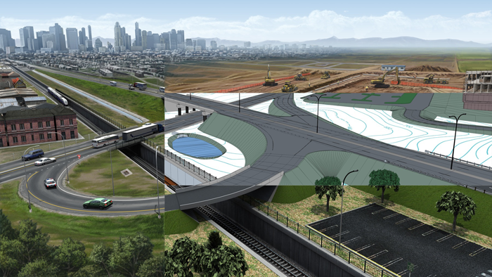
Alongside last year’s acquisition of Acute3D we saw the rapid introduction of ConceptStation, a conceptual road network design tool which combines reality modelling (photogrammetry and laser scans) with conceptual design for infrastructure projects (road, bridge etc.). This greatly simplified 3D modelling came with easy-to-use engineering sketching and the ability to produce some fantastic renders and animations.
From the 3D layouts it’s possible to assess associated project costs and share with project teams. Once the concept is approved the data can be passed on to the detailed design phase to accelerate project delivery.
Our early assessment was that Bentley was reacting to what Autodesk was doing with Infraworks (a visually rich conceptual design tool that will eventually get the documentation capabilities of Civil3D).
Roll forward a year, however, and it looks like Bentley has really taken civil design to the next level with the introduction of OpenRoads Designer – a comprehensive multi-discipline 3D modelling application which takes design from conceptual all the way to detail design and construction, blending traditional engineering workflows for plan, profile, and cross-sections with 3D parametric modelling. This is the first model-centric creation tool for all design deliverables that we have seen and quite an incredible achievement given the timescale.
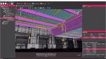
As Bentley has a single platform solution in MicroStation, the integration of reality-meshes as a standard format means all of Bentley core products can work with photogrammetry derived meshed models, as well as 2D vector, 3D solid, 2D raster and 3D point cloud. OpenRoads Designer is the first in a new line of design tools which combines the old world of documentation and modelling with meshed versions of the real world. The net result is a CAD system that has the 3D response capability of a computer game with all the advantages and accuracy of a state of the art design tool. OpenRoads Designer completes the convergence of InRoads, GEOPAK, MX, and PowerCivil. It supports all the necessary elements of roadway design including survey, geotechnical, drainage, subsurface utilities, terrain, road, roadway furniture, and more.
The incorporation of reality meshes, imagery, point cloud, and other geo-coordinated data sources give the designer continuous context of real-world conditions throughout the design and construction lifecycle. Instead of working on a blank screen, the start point of a design would be a highly detailed mesh with photorealistic bitmap of what’s occupying the site now.
OpenRoads ConceptStation could also be a kick off point and designs created in it can be opened in OpenRoadsDesigner, preserving all the work and data. All design can now be in 3D in this accurate terrain map.
Functional components
OpenRoads Designer uses elements Bentley calls ‘functional components’, which respond contextually to express appropriate design, annotation, and plan set display behaviours. The example shown at YII was of a central reservation, where the functional component was dropped onto a model road section and the reservation generated the full length of the road obeying all necessary design rules / construction codes. This could be street lighting, cabling, electrification wires for trains etc.
For the user, design models are generated and displayed in multiple live views including plan, profile, cross section, and 3D; changes in one view are live and dynamically update all views. The combination of these features should offer significant productivity time savings and will enable time for the ‘optioneering’ of many different possible designs within a typical project timeline.
Plan generation is not a separate process; they are ‘always on’, and updated from live in the model. Views are saved with specific display rules and sheet index embedded, making it easy to navigate between model and drawings. Up-todate drawings can be generated automatically at any time, creating natural and fluid modelling and detailing.
OpenRoads Designer has specific user profiles dedicated to each discipline. Users can switch discipline perspectives, for instance from Road Design profile to Subsurface Utility profile.
The software connects directly to gINT geotechnical databases to incorporate subsurface terrain details into models for improving grading and piling. Subsurface terrains can be generated or modelled based on the bore hole materials and projected in road and drainage profiles, sections, and plans. The software comes with a large catalogue of functional components for utility and drainage to model underground drainage and utility networks. Drainage models, moreover, can be optimised for water flow using integrated water analysis tools, with results available in data tables or visually in a profile view.
The deliverables extend far beyond the traditional plan sets and animations, as the digital construction models enable automated machine control and field positioning systems including for excavation, grading, piling, and paving. At the conference Bentley Systems’ CEO, Greg Bentley quipped that while everyone is talking about driverless cars coming, Bentley with partner companies like Topcon are already remotely driving many grading vehicles on construction sites around the world.
OpenRoads Designer directly integrates with Bentley LumenRT for producing image and animations with lifelike vegetation, reflecting nature and climate, and for traffic simulation with VISSIM.
Conclusion
The civil and construction sector has caught the eyes of many of Bentley Systems’ competitors, but especially Autodesk. While Civil3D and Infraworks continue in parallel, Bentley has jumped the chasm. To go from the Acute3D acquisition last February in 2015, to ConceptStation and now OpenRoads Designer shows that Bentley is doubling down on its civils and transport Infrastructure development.
Finally, decades of acquisitions, development and platform regeneration can be seen in the capabilities of this software. While Bentley Systems is a master of the subscription- based incremental update, this year a number of engineering projects have combined to create what looks to be the ‘100 year wave’ in terms of advancements with the OpenRoads CONNECT Edition.
This article is part of a Bentley Systems Year In Infrastructure special report. Read the other articles below
The age of the reality mesh: Bentley Systems is forging ahead with Reality Capture by embedding reality meshes into its foundation platform.
Cloud analytics: Knowledge is power Bentley is helping engineers ‘design out’ delays before they happen, by giving them access to real-time supply info.
The future of AR: The HoloLens and the use of reality meshes have got round tracking issues, paving the way for new AR applications.
LumenRT embraces VR: LumenRT, an easy-to-use real time viz tool with a powerful ‘game engine’ environment, now offers VR support.
Bentley Systems futures: Bentley Systems may still be preparing for an IPO, but there has been some important news on its relationship with Siemens that could have big ramifications in the future
If you enjoyed this article, subscribe to AEC Magazine for FREE