Sleek lines and ease of use mark the arrival of a new breed of 3D scanner from Leica Geosystems. Stephen Holmes finds a rare case of luxury Swiss design that can be used by architects and others – not just surveyors
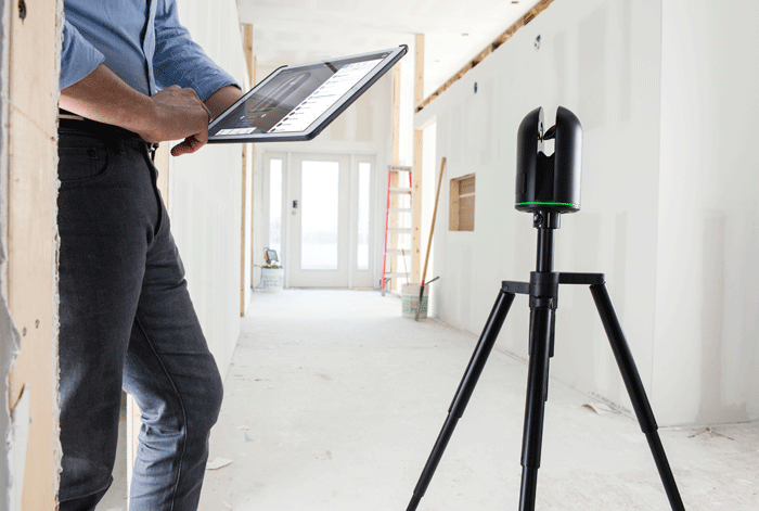
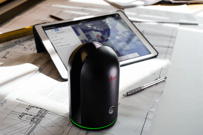
Small, lightweight, black anodised aluminium, and with just a single button, the Leica Geosystems BLK360 is barely recognisable as a professional-grade 3D scanner.
That button, however, unleashes its inner purpose — once pressed, three minutes later you have a full 3D scan of a room, in a combined laser, photogrammetry and heat-mapped model that is ready to be used instantly in Autodesk ReCap Pro from a partnered iPad.
When giving AEC Magazine a demonstration of the new BLK360, Hexagon Geosystems CTO Burkhard Boeckem explained that its purpose is the ‘democratisation of reality capture’: allowing everyone, not just surveyors, to collect scan data, increasing the impact that scan data can have on the design and engineering workflow.
For the creation of the BLK360, Leica created a special group; evolving a competition design (brief: ‘It should not look like a scanner, but a timeless luxury item’) with its own design heritage, such as the Leica T2 theodolite; kitting it out via a trip ‘technology shopping’ through the vast innovation stores of its parent company Hexagon, before miniaturising the entire platform.
From the pin-prick hole in the self-balancing mirror arm for noise cancellation, to the custom-built fold-flat tripod, Leica has gone about this project with a painstaking eye for detail, with each unit hand assembled at its Heerbrugg headquarters in Switzerland.
It’s an eye-catching product, but it’s not lagging on the performance front. Leica states that its infrared scanner captures 360,000 points per second within a 60m range, while the HDR imaging is performed by a 15MP threecamera system that is calibrated for full spherical HDR imagery.
According to Leica, this sets up a 3D point accuracy of 6mm at 10m, creeping to 8mm at 20m.
The thermal camera integration is aimed at the AEC market and features a professional unit from infrared expert FLIR that is fully calibrated with the rest of the collected data points.
The addition of accurate thermal overlays should prove useful for showing pipes, cables and other embedded fixtures that might not be immediately visible from a surface scan.
However, its biggest asset is its ease of use and it is designed to allow anyone to go out, set it down and collect accurate scan data with little fuss. The scan settings from the single button start can be configured from within the software, should you wish.
The unit is protected by a plexiglass cover mimicking the original T2 theodolite design, but otherwise its rotating base and optional tripod are the only travel companions it needs. Its 1kg form can easily fit into carry-on luggage or a discreet messenger bag on the London Underground.
There are no cables required and while the scanner alone will store over 100 reality captures, the BLK360 acts as its own WiFi router, sending scans direct to partnered devices (iPad Pro at present, with Android to come soon).
Battery life is good for 40 scans, says Leica, explaining that a single residential house needs around 12 on average. Inbuilt LED lighting and weather proofing to IP54 standards mean it can be used both indoors and out.
The relationship with Autodesk ReCap Pro serves a dual purpose: not only is the data immediately available to review on the iPad in situ (meaning fewer faulty scans, or details missed), but the data can be then sent anywhere in the world with a few clicks.
Billed by Autodesk as ‘rapid, reliable and robust’ the data is available in Autodesk’s native RCS (individual) and RCP (project) file formats ready for the Autodesk environment, including Revit and 3ds Max, as well as E57, PCG and PTS file formats that can be exported.
Featuring an intuitive user interface and ease-of-use controls, the aim of ReCap Pro is to speed up the capture workflow, meaning more room for verification, with fewer errors.
Asked where this product would fit into his company’s process, Lewis Wenman, lead BIM manager at Bouygues UK, a Beta tester of the BLK360 in London, replied: “I thought this was game changing in the whole workflow.”
“The availability of doing this, the accessibility, the light weight, the process, it’s just going to change the way we think about utilising point clouds.
“At the moment, it’s deemed quite an expensive and time-consuming process – this changes things completely.”
Then there’s the price; the BLK360 launches at $15,990, including a year’s subscription to Autodesk ReCap Pro with support. Once the investment in an iPad Pro has been made, this is hardly throwaway kit, but it is within the bracket marked ‘attainable’.
By Leica’s own admission, the BLK360 isn’t the furthest it has pushed 3D scanning technology. This is a tool for the single scan jobs like capturing an interior layout, with Leica Geosystems offering better suited tools for projects requiring greater amounts of detailed reality capture.
This product, alongside Bentley’s ContextCapture, Google Tango and DotProduct’s technologies, signals a sea change in the democratisation of reality capture — a revolution of use and availability. For Leica Geosystems, the BLK360 is by far the most beautiful of all its technologies, but it also looks to be one of the most accessible.
If you enjoyed this article, subscribe to AEC Magazine for FREE