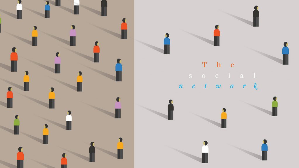
As people return to shared spaces such as offices, transport hubs, and construction sites, Greg Corke highlights 20 technologies that can help AEC firms and facility owners plan, function and mitigate risk in a socially distanced world
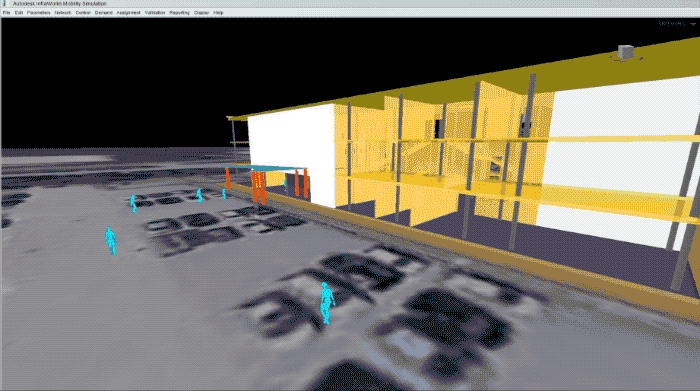
Autodesk Infraworks
Pedestrian simulation
Autodesk has been exploring how its civil infrastructure design software InfraWorks can be used to conduct pedestrian mobility simulations that factor in current global design challenges presented by Covid-19.
The software’s multi-modal ‘Mobility Simulation’ engine is typically used for transportation projects to analyse door-to-door journeys, through mass transit, biking, or walking, but it can also be used to simulate pedestrian mobility in indoor environments, such as a large retail space, an airport terminal, or a shared office space.
In a recent blog post, Autodesk explores how the software can be used to perform a basic mobility simulation. It accounts for physical distancing constraints between pedestrians as they enter a threestorey shared office from the car park then continue into the building until they reach their desks.
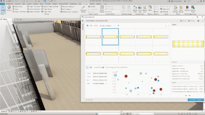
Autodesk Revit 2021: Generative Design
Space planning
Autodesk has been exploring how the new Generative Design capabilities in Revit 2021 (available only to subscribers of the AEC Collection) can be used to help redesign the layout of interior spaces.
For an open plan office, Autodesk demonstrates how the software can help maintain a safe physical distance between employees, focusing specifically on the arrangement of desks, taking into account the width and spacing of aisles, the density of seating, and the importance of window views for staff wellbeing.
In a worked example for a restaurant layout, Autodesk goes one step further, using the Path of Travel tool to understand traffic flow through the space. Tables with less circulation near them should be considered for seating first during the operation of the restaurant to minimise exposure as people are seated.
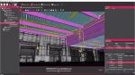
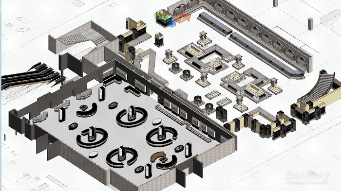
Bentley OpenBuildings Station Designer and LEGION
Pedestrian simulation
Bentley is using a combination of BIM, generative design and pedestrian simulation to help architects, facilities owners and consultants adapt existing projects or plan and test new safety and security strategies for public spaces. These include stations, airports, hospitals and stadiums. The software can help maximise space utilisation, as well as model safe and comfortable wayfinding strategies and evacuation plans.
Bentley’s solution centres on two products: OpenBuildings Station Designer and Legion Simulator, which Bentley acquired in 2018. Bentley has waived new subscription fees until 30 September 2020.
Currently, the two products are not that tightly integrated, but this will change in the next month or so. Bentley is adding model prep functionality into its OpenBuildings Station Designer so it can automatically create a model that can be used for pedestrian simulation. The idea is that objects within the BIM model are given an added layer of intelligence. A ticket barrier, for example, will know how long it takes for a pedestrian to pass through.
Currently, model prep is done in a standalone application called Legion Model Builder. Users import an IFC, Revit, DWG or DGN file, convert it to a 2D plan, add objects, define the number of people in the simulation, and then the scenarios (rush hour, match day etc.). Once everything’s set up, it generates a file that goes into Legion Simulator which does the actual pedestrian simulation.
To help plan for, and to reinforce, social distancing, Bentley has added some specific features. Generative Components, the generative design technology built into OpenBuildings Station Designer, can be used to help develop queuing strategies, with the automatic placement of floor stickers or waiting zones. In Legion, proximity bridge maps show how many people got too close during any particular scenario.
Bentley is also developing tools to help consider how social distancing will impact transportation networks, as Eduardo Lazzarotto, director of product management at Bentley Systems explains “We’ve worked with TfL [Transport for London] to write a script to analyse raw data out of simulations to help define how many trains can be operated at that station or how many passengers can actually go through that space.”
Work is being done on a lot of the critical stations in London, including Clapham Junction, Waterloo, Victoria and Finsbury Park. “They’re defining the action points for the station manager, which is pretty much ‘OK, when you reach this number of people you need to close the barriers, nobody enters, we need to wait for people to leave and then we continue operation’,” says Lazzarotto.
One of the biggest challenges for pedestrian simulation is accurately modelling pedestrian behaviour. When Legion was originally developed it gathered masses of real world data from cameras installed in different stations, airports and stadiums, etc. This was used to understand, for example, how people approach an elevator / escalator, or how they queue or wait, and so on.
Operators can also help improve the accuracy of their simulations, as Lazzarotto explains, “TfL did a trial a couple of years ago with their WiFi beacons in stations, triangulating the location of passengers and understanding pretty much where they stay inside the station. They can also cross reference that data with the ticket gate information of how many people enter and leave a station.
“Some operators like Network Rail use infrared cameras to understand how many people are buying a coffee before they go to the train. And how many people are running to catch the train, and how many people are waiting for the next one.”
Of course different cultures behave differently and the software comes with profiles based on statistical analyses of real people in different cities and sites around the world. London Underground commuters know the drill — head down, elbows out, always stand on the right — but a model based on that behaviour wouldn’t be applicable to the Riyadh Metro in Saudi Arabia.
The big question is, will behaviours change with social distancing? Will people become more cautious and aware of space, or take more time for journeys. If that happens, the Legion team will certainly recalibrate some of its profiles, Lazzarotto confirms.
This all leads into the concept of the Digital Twin, where real world data from IoT devices is continually fed back into the model to help improve the accuracy of future scenario testing. At the moment this is done manually, but it could change.
“We are striving to connect the data automatically into the process, to create feedback loops,” says Lazzarotto. “But at the same time we see at least in the foreseeable future there will always be a space for the decision maker to make the decisions based on that data.
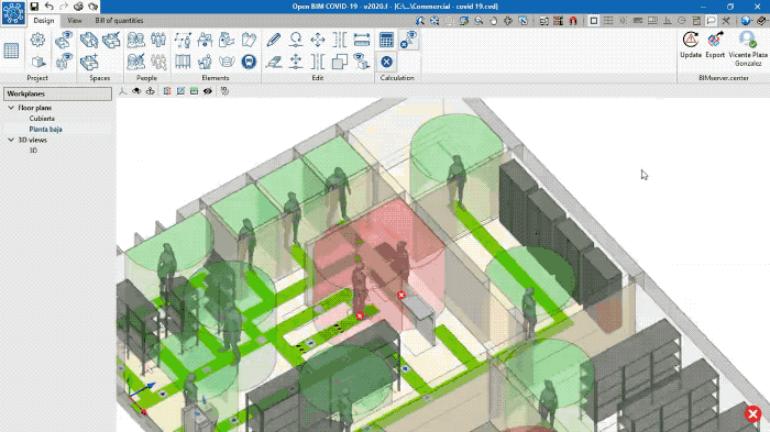
Cype Open BIM Covid-19
Space planning
Spanish AEC software developer Cype has developed a free tool to help minimise the spread of the virus through the planning and implementation of safety measures in buildings and open spaces.
Open BIM Covid-19 can be used to optimise the space of facilities as well as design circulation and evacuation routes. It takes into account criteria such as interpersonal safety distance, placement of furniture and the installation of separators. A second phase of development will allow users to analyse the pattern of virus dispersion and spread in buildings using Computational Fluid Dynamics (CFD), taking into account the speed and dispersion pattern of particles in coughs and sneezes.
Based on Open BIM technology, and using IFC 4.0 files, Open BIM Covid-19 allows the results to be viewed in 2D, 3D, Augmented Reality or Virtual Reality.
The software also generates detailed reports containing the maximum allowed capacity together with graphic documentation to design the most appropriate layout. In this way, business managers, for example, can optimise the space of their facilities, whether they are shops, restaurants, hotels or commercial buildings. The software can be adapted to the national safety regulations against Covid-19 of ‘any country in the world and at any phase’. In Spain, Cype has followed the criteria established in the BOE (Official State Gazette). BOE requires the installation of bins and the provision of hydroalcoholic gels or disinfectants with viricidal properties authorised and registered by the Department of Health to clean hands or, when not possible, soap and water.
Digital Blue Foam Covid Space Planner
Space planning
Data-driven generative design specialist Digital Blue Foam is developing a web-based tool to help address the risks associated with the use and occupancy of interior spaces.
Covid Space Planner analyses factors such as total occupancy and proximity, airflow and ventilation, and the duration of activity in the space. Based on these factors, the tool applies Digital Blue Foam’s generative design capabilities to recommend spatial planning strategies, such as the location of entry points, work areas, furniture placement, and retrofits, to mitigate the risk.
Digital Blue Foam is currently working on a free version which it intends to make available to small business owners during the pandemic. The Singapore-based company is in contact with experts in medicine, Computational Fluid Dynamics (CFD) analysis, and wayfinding to develop new capabilities around airflow simulation and risk assessment.
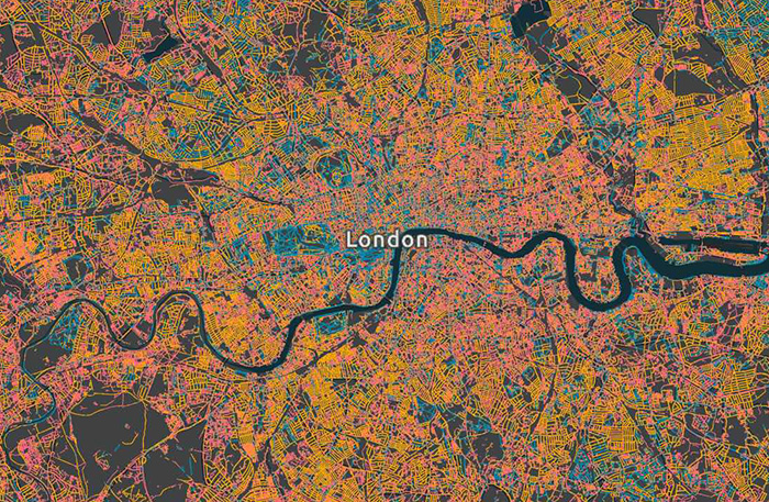
Esri GB Pavement Width Indicator
Space planning
Esri UK has used spatial analysis to create a map of pavement widths around Great Britain. The data has been made available for free to help the public sector and other organisations respond to guidelines for social distancing, as councils adapt infrastructure to make walking safer for the public. Esri discovered that 30% of pavements are at least 3m wide, 36% are between 2-3m and 34% are less than 2m.
“This map is a vital tool to help us find the right solutions to support social distancing. Where it may not be feasible or cost-effective to look at extending pavement space, we can review other options such as clamping down on pavement parking and reducing speed limits, to cut danger on residential streets,” said Oliver Penman, senior information officer, GCC Corporate GIS, Glasgow City Council.
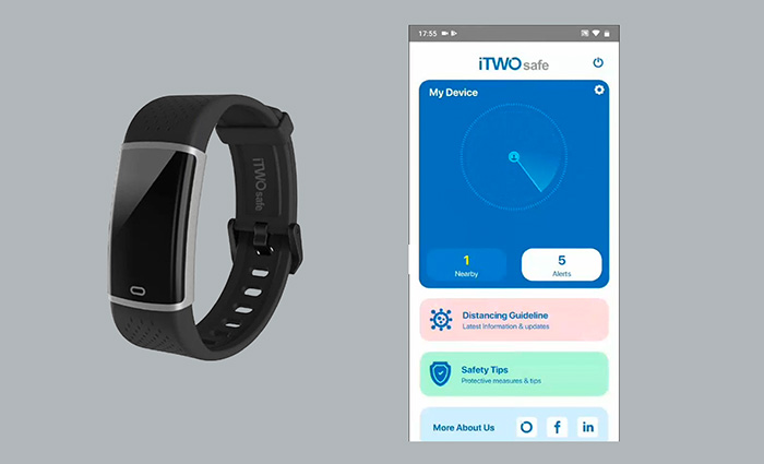
iTWOsafe
Real time monitoring
iTWOsafe is a new ‘smart distancing’ technology that can help maintain social distancing on construction sites or in offices. The technology monitors and tracks physical distancing using a smartphone app and a light-weight Bluetooth Low Energy (BLE) device, which comes in the form of a wristband or clothing tag.
By linking the two together, the solution can be used to measure distances between workers and give an alert before a set distance is breached – the idea being that workers can work safely without worrying about how close they are to colleagues. iTWOsafe can also provide reports including a traceable contact history for infection emergencies.
iTWOsafe is developed by RIB Group and A2K Technologies and is available in the UK from Cadline.
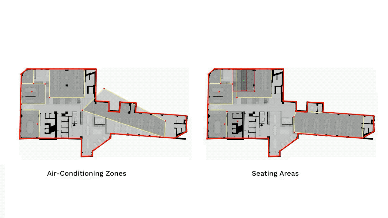
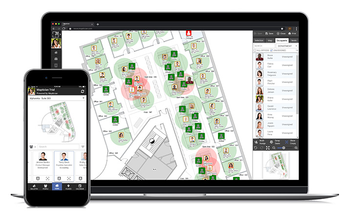
Maptician Flex
Space planning
New features in Maptician’s cloud-based workplace management platform are designed to help firms reopen offices post lockdown. Maptician Flex has a big focus on planning with tools for social distancing and staggered work schedules. But there’s also an emphasis on employee communication to help workers return to the office.
Social distancing analysis helps firms identify risk within pre-Covid-19 seating layouts as well as in conference rooms, open areas, breakrooms, and walkways. Contact tracing can identify individuals who sat in the proximity of a person who tested positive for Covid-19.
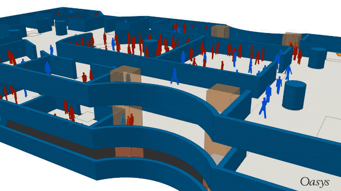
Oasys MassMotion
Pedestrian simulation
MassMotion is a crowd and pedestrian flow simulation tool developed by Oasys, the software arm of Arup. The commercial product is designed to test designs from a human perspective, to help understand how people move though space. MassMotion simulates human behaviour through the use of virtual agents, taking into account congestion, efficiency of flow and many other factors.
MassMotion is used by architects, urban planners, property owners and facilities managers to help design and understand a range of buildings and facilities, including train stations, airports, museums and stadiums – in fact, any space that you find a crowd.
Since the introduction of social distancing, the emphasis has shifted from working out how to maximise the flow of people, to exploring and quantifying different mitigation strategies and how changes to designs or operations can help reduce risk when reopening facilities.
To do this several new features have been added to the 10.6 release that allow users to better understand the impact of different social distancing scenarios, and how pedestrians might interact and for how long.
This includes a proximity analysis tool that allows users to assess a MassMotion model and report on all agents that move within a given distance threshold of each other, such as 2m. As the simulation runs, MassMotion highlights agents that are effectively socially distanced (blue), and those that are not (red).
But it’s not just about visual reporting. There are also tools to measure and map the durations and interactions of people, calculate the capacity of a given space while maintaining a set physical distance, or assess if different elements of a journey are affected disproportionately.
Of course, government guidelines on distance aren’t necessarily followed by everyone, so it’s possible to give different groups of agents different ranges of personal space, which they then attempt to socially distance.
“It’s all good and well to have new metrics and new ways to understand space, but if we’re not at least making an attempt to reflect reality, and to reflect the way that people move throughout some of these spaces, I think we won’t be reporting on something that’s reasonably accurate,” says Lachlan Miles, MassMotion product director.
Oasys has several examples of how the software can be used, including testing different strategies for socially distanced queues at airport security and another that explores the difference between 2m and 1m of social distancing and what it means in relation to the operation of a commercial building or a stadium.
Foster + Partners is using the software to analyse pedestrian movement and quantify public space strategies for a residential neighbourhood – part of a masterplan project for South Sabah Al-Ahmed City, located 80 kilometres south of Kuwait City.
Space Explorer
Arup has taken MassMotion and combined it with data and spatial analysis tools, to launch Space Explorer, a new service designed to help employers optimise their workplaces in the emerging postpandemic phase. Read this AEC Magazine article for more details.
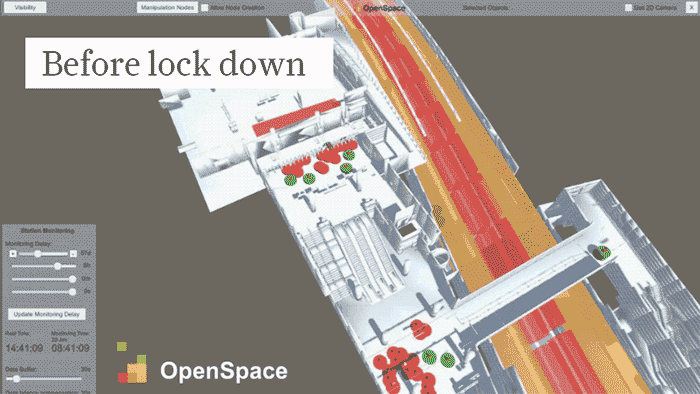
OpenSpace
Space planning
UK startup OpenSpace has developed a platform that uses IoT and AI to detect and visualise the distance between pedestrians in real-time. The technology uses cameras with computer vision to measure pedestrian flow rate, travel patterns and social distancing. The resulting data can then be used to compare historical weekly and daily information for trend analysis.
The technology is currently being used at London St. Pancras station. It was originally designed to alert station managers to overcrowding, but is now monitoring social distancing. Through the use of VR headsets, operators can also put themselves in the shoes of passengers in real-time — like those approaching a crowded area to see and feel some of what customers are feeling, to help drive improvement strategies.
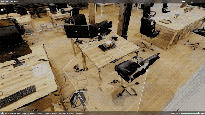
PreVu3D Covid-19 solution
Space planning
PreVu3D has developed a social distancing design tool to help firms rethink the layout of office spaces. Users can upload data captured by laser scanner (point cloud) or photogrammetry (meshes) to create a 3D environment that can be navigated in freeview (fly) and first person modes. PreVu3d technicians can also come on site and 3D scan a space.
To plan for social distancing, the software can be used plot circulation routes, take measurements and add annotations. To increase spacing between desks and workstations, smart selection tools can extract objects from the reality model (such as a desk and chair) so they can be moved to a new location.
prevu3d.com/social-distancing-design-tool
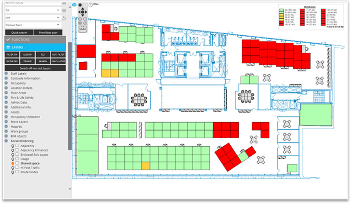
QFM Return2Work
Space planning
QFM Return2Work is a new space and desk management solution designed to help Facility Managers (FMs) manage the safe return of employees and visitors to the workplace.
Graphical floorplans allow FMs to see ‘at risk’ areas as coloured overlaps, highlighting the number of times a desk or person would be in breach of social distancing guidelines. New layouts can then be designed and evaluated (either manually or automatically created by the software) to find the best solution for each area.
Simulation software (various)
Computational Fluid Dynamics (CFD)
Computational Fluid Dynamics (CFD) software allows engineers to delve into the science of how Covid-19 might spread through the air. This can be on a micro level, to explore person to person transmission, or on a macro level to get a broader understanding of airflow and the impact of air conditioning in buildings.
Ansys has used CFD to demonstrate how person to person risk decreases significantly at 2m because gravity pulls the carrier droplets to the ground.
Engineers at MSC Software have carried out various studies that focus on breathing, speaking, coughing and sneezing in confined spaces, including a metro car with background air-conditioning.
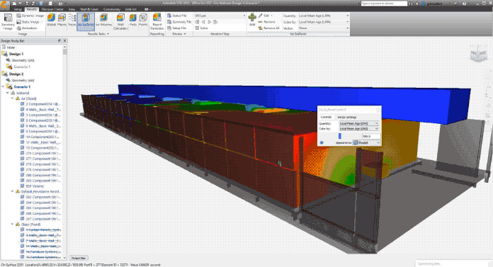
Autodesk has demonstrated how its CFD software can be used to assess airflow inside buildings to help firms better understand which situations might place employees at a greater risk. The software can be used to explore the effectiveness of the airflow, the rate of air change, and to identify specific areas of concern. Different strategies can then be explored to help reduce risk, such as moving desks, adding space dividers, moving diffusers or increasing air filtration.
SimScale and Dassault Systèmes have several tools to help with HVAC design in buildings. Most CFD tools are for experts — consultants or HVAC engineers — but Ansys Discovery Live can provide architects with easy-to-use real-time simulation tools for exploring concepts.
Smartvid.io
Real time monitoring
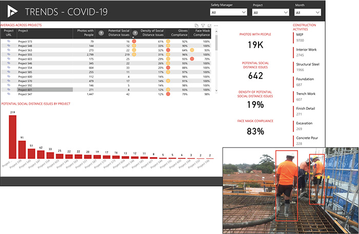
Smartvid.io has added new functionality to its AIpowered safety platform to help contractors reduce the risk of Covid-19 outbreaks on construction sites.
The software uses images or videos captured by onsite cameras, then uses its AI platform ‘Vinnie’ to automatically measure social distancing (i.e. to see whether workers are less than six feet apart or in larger than permissible groups) or to check if PPE face masks are being worn. The data can then be used to automatically create statistical reports to measure the percentage of workers in compliance.
By design, Smartvid.io does not use facial recogition and VP of product management Dmitry Grenader stresses the importance of using data appropriately. “If it’s used to nail people for non-compliance, the program will not be very effective. Instead, focus on positive compliance to drive behaviour. Once you know which sites are at highest risk, you can provide additional training and look closely at the environment to determine the role it could be playing.”
Barton Marlow, one of the top 50 contractors in the US, has been using the technology to help implement a Covid-19 mitigation plan.
Spacewell
Real time monitoring
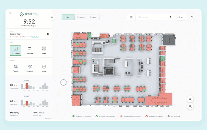
Building operations and management specialist Spacewell has developed a smart building solution that uses IoT technology to monitor space utilisation and help firms maintain socially distanced offices.
Digital occupancy maps include a ‘real-time crowdedness’ indicator across different floors to help employees steer clear of busy spaces and reduce the risks of viral transmission.
Spacewell is part of the Nemetschek Group, which also owns Vectorworks, Graphisoft, and Allplan.
Triax Proximity Trace
Real time monitoring
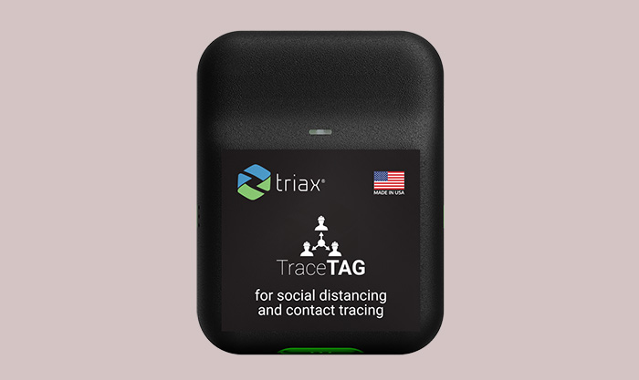
Triax Technologies has introduced a new Internet of Things (IoT) technology called Proximity Trace that provides proximity distancing alerts and contact tracing for construction sites.
‘TraceTags’, which are worn on the body or affixed to a hardhat, will emit a real-time visual and audible alert when workers get too close to each other. All close proximity interactions, including duration, are recorded on the TraceTag until it gains connectivity to one of several ‘gateways’ placed strategically on site at exits and high traffic areas. The gateway then transmits the data to the cloud, where it can be viewed and analysed on a dashboard. A log of all worker interactions is kept for contact tracing, should there be confirmed case of Covid-19 on the construction site.
Beyond technology
Technology has an important role to play as we move out of lockdown, but it’s nothing without a well thought out strategy. Here are some valuable sources of information from leading AEC firms to help make public and private spaces safer.
Arup: Future of offices in a post-pandemic world
Atkins: Safer Public Places: Integrating Social Distancing
Cushman & Wakefield: Recovery Readiness: A How-to Guide for Reopening your Workplace
Buro Happold: Engineering healthy workplaces – considerations in response to Covid-19
If you enjoyed this article, subscribe to our email newsletter or print / PDF magazine for FREE